|
2 应用――一个案例研究
上述景观生态安全格局方法论被用于广东丹霞山国家风景名胜区的生物保护规划中,研究范围 300多平方公里,位于南亚热带和中亚热带的过渡性地区,生物多样性很高。研究通过 ARC/INFO地理信息系统 (GIS)来完成。本案例的生物保护安全格局的判别步骤如下。
2. 1 源的确定
本案例研究中选用 3类有代表性的物种作为保护对象,包括中型哺乳类、雉类和两栖类 [25,27]。通过以他们作为假想目标,目的是为了保护生境的多样和潜在的景观生态基础设施。限于篇幅,本文只介绍林中雉类的保护安全格局的判别方法,作为林中雉类的源是风景区内现有的 7个残遗自然斑块,属保存完好的淮南亚热带季雨林斑块 (图 2)
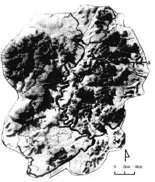
图 2 丹霞山全景及残遗斑块 (淮南亚热带季雨林斑块作为保护源 )
Fig. 2 The overall landscape of the Red Stone National Park and the remnant patches ( monsoon forest patches as the sources of ecological processes)
a.残遗南亚热带季雨林斑块 Remnant monsoon forest patches
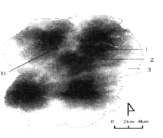
图 3 林内雉鸡运动阻力面
Fig. 3 Resistance surface for the movem ent of pheasants
1残遗自然斑块 Remnant forest patch, 2低阻力区 Low resistance surface, 3高阻力区 Hight resistance surface
2. 2 阻力面的建立
如前所述,阻力面是运用最小累积阻力模型来建立的。首先是对景观根据其对保护对象空间运动的阻力进行等级的划分 [25]。景观对物种的相对阻力是参照有关文献来确定的 [21,35]。在本案例中,有理由认为植被类型与残遗栖息地斑块的植被特征越接近,其对物种运动的阻力就越小。为此,根据植被受人为活动干扰的强度划分为 6个等级,从受干扰强度最大的农田、到草地、灌丛、针叶林、混交林和人为干扰强度最小的季雨林残遗斑块。在上述阻力分级评价基础上,再将生态源与距离的因素考虑进去,运用 MCR计算方法,便得到一个反映物种运动时空动态和趋势的阻力表面 (图 3)
2. 3 根据阻力面的空间特征判别生态安全格局
除了已确定的源以外,生态安全格局的其它各组分都可以根据阻力面的空间特征来判别。
2. 3. 1缓冲区 从 MCR阻力面上 (图 3),可以得到两类曲线,第一类是反映离源距离和MCR值关系的剖面曲线 (图 4),这一曲线上反映了多级门槛值的存在,证实了上一章的假设。
另一种 (一条 )曲线则综合反映 MCR值与面积的关系 (图 5),正如所设想的,其中也反映了一些门槛值。图 5曲线上的点 b1~ b5是一些可识别的门槛值。在这些点附近随着缓冲区范围的扩大或减少, MCR值发生急剧性变化。所以,如果将缓冲范围扩展到一定边界之后,所增加的面积的可利用性及其保护意义会急剧下降,则这样的一些门槛值可作为缓冲区划分的依据。
如,有关研究表明,全区内至少有 50%以上的土地应作为保护区才有利于物种的空间运动不受景观破碎化的影响 [36]。为此,可以确定图 5中的点 b3是一个比较理想的、用来确定缓冲区范围的门槛值,这时缓冲区范围内的面积可达到52%。这一缓冲区的边界与 (图 4)剖面曲线上的点 a2门槛值相对应。得到如 (图 6)的相应的缓冲区形状和格局。如果降低安全标准,则可以用图4中的 a1和图 5中的 b1点为门槛值划分缓冲区,则相应地得到如 (图 7)的缓冲区和分布。
2. 3. 2 源间联接 每一源和其它任一源都有一条或多条低累积阻力谷线,其中有一条是最小阻力谷线。多一条联接就可以为某一源的保护多一份保险。安全层次就可提高。如果使每一源与其任何相邻的源都有一联接通道,则可得到如 (图 6)的高度安全的源间联系。如果降低安全标准,则可选择如 (图 7)的源间联接。这种情况下,每一联结至少被同时用于 3个源之间的联系。
2. 3. 3 辐射道 辐射道是阻力表面上自源向外发射的低阻力谷地,形同枝状河流水系。这是生物以原有栖息地为基地,向外围景观扩散的有效途径。高度安全的保护格局应具有这种景观组分 (图 6)。
2. 3. 4 战略点 景观点略点有多种 [27]。这里只介绍一种,即鞍部战略点,它们是相邻源等阻线的相切点,起源间“跳板”的作用 (图 6,图 7)。
将上述各种安全水平上的战略性景观局部和位置及空间联系组合在一起,就构成了两种不同安全水平上的景观生态安全格局:高度安全的生物保护安全格局 (图 6)和中等安全水平的生物保护格局 (图 7)。
这些以单一物种或某一群体物种保护为目标的景观生态安全格局再经叠加,可以得到以保护多个类型生物群体为目的的生态安全格局 [29 ]。
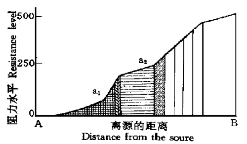
图 4 阻力面上一典型剖面 (图 3中的 A点到 B点 )
Fig . 4A cross section from a source A to a point B at the far end of th e resistance surface ( refer to figure 3 for the location)
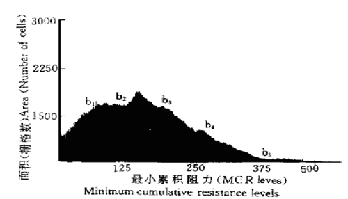
图 5 面积与阻力直方图显示门槛值的存在
F ig. 5 The area-resistance level histogram suggests the existence of step -wise thresholds
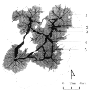
图 6 高度安全水平的雉类保护安全格局
Fig . 6 Security pattern for th e protection of pheasants at a highly secure level
1缓冲区 Buffer,2残遗自然斑块 Remnant forest patch(sou rce),3战略点 Strategic point,4源间联结 Inter-source linkage,5辐射道 Rad iating route
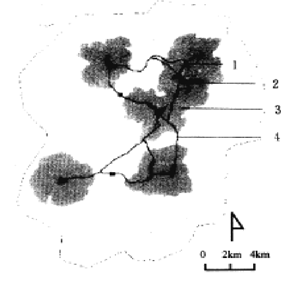
图 7 中等安全水平的雉类保护安全格局
F ig. 7 Security pattern for the p rotection of ph easants at a m od erately secure level
1战略点 Strategic point, 2残遗自然斑块 Remnant forest patch ( source) ,3缓冲区 Bu ffer, 4源间联结 Inter-source linkage
3 讨论
本研究将水平生态过程作为一种对景观的控制过程来对待。通过对关键性景观局部、位置和空间联系的控制,和栖息地的布置形成某种战略性格局,有可能形成超越于实际存在的景观元素以外的强有力的生态势力圈 (ecological influence sphere)从而使某种生态过程的健康与安全得以有效的维护。 SP方法旨在判别、维护和强化景观生态基础设施。判别 SP是为了指导景观改变而不仅仅是对现存景观的描述。理论地理学的表面模型对判别保护区生态安全格局有启发意义。
本文揭示了一般表面模型的点和线的特征与景观生态学和生物保护学中的景观结构之间的关系,证实了生态过程动态趋势中某些门槛值的存在,并进一步讨论了如何应用这些门槛值定义缓冲区。从而为缓冲区的划分提供了一条新途径。
安全格局的功能组分基本上与景观生态学的景观分析模型相对应,如斑块、廊道和基质模型 (6)。一个安全格局意味着如何选择、维护和在某些潜在的战略部位引入斑块,使他们成为“跳板”,意味着如何来构筑源间联系廊道和辐射道。导致生态安全格局部分或全部破坏的景观改变对于某种生物保护安全水平说是不能接受的,因为它将导致生态过程的急剧恶化。一个可接受的生态规划和景观改变就意味着维护和强化生态安全格局。这有利于减少景观改变决策失误所导致的不可逆转的后果。本研究将安全、格局和改变等概念结合起来的本质意义在于把生物保护规划作为一个可辩护的、空间交易和发生在多个利益辩护者之间的博奕过程。
本文讨论的表面模型计算方法在很大程度上是带有假设性的,具体应用时可能需要更复杂或更简单的模型。在这一理想化的计算模型中,只考虑了源的位置、空间距离和景观基面特征。其它因素如源本身的结果和组成,驱动力因素的存在等都有可能影响阻力面的生成。本文还着重强调了 SP方法与传统生态规划的叠加模式之间的不同点,而着重讨论水平生态过程。实际上,两种方法是可以互为补充的。尽管论文讨论了林中雉类空间运动及其保护的安全格局,方法同样适用于其它动物的保护,也适用与其它生态过程如火灾的蔓延,虫灾的扩散等安全格局的判别。最后需声明的,案例研究只作为方法论的说明,作为实际应用还不成熟。
参考文献
[1]Frankel O H and Soulé M E. Conservation and Evolution. CambrigeUniversity Press. 19 81
[2]Harris L D. The Fragmented Forest:Island Biogeography Theory and Preservation of Biotic Diversity. University of Chicago Press, Chicago, IL, 19 84
[3] Noss R Hand Harris L D. Nodes, networks, and MUMs:Preserving diversity at all scales. Environmental Manag ment, 19 86, 10(3) :299~ 309
[4] WRI, IUCN and UNEP. Global Biodiversity Strategy:Guidelines F or Action to Save, Study and Use Earth' s Biotic Wealth Sustainably and Equitably, 1992, WRI/IU CN/UNEP
[5] Smith D S and Hellmund P C S. ( Editors) , Ecology of Greenways. University of Minnesota Press, Minneapolis, M N,1993, 69~ 104
[6] Forman R T T. Some general principles of landscape and regional ecology. Landscape Ecology, 1995, 10( 3) :133~142
[7] 俞孔坚 ,李迪华 .城乡与区域规划的景观生成模式 .国外城市规划 , 1997, 3:27~ 31
[8] Faludi A . Decision- centered View of Environm ental Planning. Pergamon Press, 1987
[9] Steiner F, Young G and Zube E. Ecological planning:Retrospect and prospect. Landscape Journal, 1987, ( 7) :31~ 39
[10] M c Harg I. Desig n With Nature. John Wiley & Sons, Inc. 1969 ( 1992edition)
[11] M c Harg I. Human ecological planning at Pennsylvania. Landscap e Planning, 1981, ( 8) :109~ 120
[12] Olsson G. Distance and Human Interaction:A Review and Bibliography . Regional Science Research Institute, Philadelphia, 1995
[13] Bartlett M S. The Statistic Analysis of Spattern Patter ( 1st edition) . Chapman and Hall, L ondon, 1975
[14]Sklar F H and Costanza R. The development of dynamic spatial models for landscape ecology:Areview and prognosis. In:Turner M G and Gardner R H S. ( Editors) , Quantitative M ethods in L andscape Ecology. Springer- Verlag, New York, 1990
[15] Johnson W C. Estimating dispersibility of A cer, F raxinus and Tilia in fragmented landscapes from patterns of seedling establishment. L and scape Ecology, 1998, 1( 3) :178~ 187
[16] F relich L E. Calcote R R and Davis M B. Patch form ation and m aintenancein an old - growth hemolck-hardwood forest. Ecology , 1993, 74( 2) :513~ 527
[17] W arntz W . The topology of a social- economic terrain and spatial flows. In:( Thomas M D S) , Papersof The Regional Science Associatio. U niversity of W ashington, Philadelphia, 1966, 47~ 61
[18] Chorley R Jand Haggett P. Trend-surface mapping in geographical researearch. In:Berry BJL and M arble D F . ( Editors) . Spatial Analysis:A reader In Statistical Geography. Prentice Hall. Inc. , Englewood Cliffs, N ew Jersey, 1968, 195~ 217
[19] Warntz W . Geography of prices and spatial interaction. In:Pap ers and Proceedings of the Regional Science Association, 1957, 118~ 129
[20] W arntz W . Geography and The Properties of Surfaces, Spatial Order Concepts and Applications. H arvard Papersin Theoretical Geography, 1967, ( 1) part 1
[21] Form an R T T and Godron M. Landscap e Ecology. John W iley, New York, 1986
[22] Turner M G. 1989. Landscape ecology:the effectof pattern on processes. Annual Review of Ecology and Systematics,1986, 20:171~ 197
[23] Laver C J. and Haines-Young R H. Equilibrium landscapes and their aftermath:Spatial heterogeneity and the role of the new technology. In:Haines-Young, R, Green D R and Cousins S. ( Editors) , Landscap e Ecology and Geographic Information Systems. Taylor & Francis, London, 1993, 57~ 74
[24] Knaapen J P, Scheffer M and Harms B. Estimating habitat isolation in landscape planning. L andscape and Urban Plann. 1992, ( 23) :1~ 16
[25] Yu, K-J. Security Patternsin Landscape Planning:W ith a Case In South China. Doctoral Thesis, Harvard University,1995
[26] Yu K-J. Ecological security patterns of landscapes:concept, m ethod and a case. In, Proceeding sf or International Symposium of Geoinf ormatics' 95, Hong Kong, 1995, 396~ 405
[27] Yu K-J. Ecological security patterns in landscape and GISapplication. Geograp hic Inf ormation Sciences. 1995, 1( 2) : 88~ 102
[28] Yu K-J. Security patterns and surface model in landscape planning. L andscape and Urban Plann. 1996, 36( 5) :1~ 17
[29] Yu K-J. Security patterns:a defensive approach toward landscape and environmental planning. In, Sellis T and Georgoulis D( eds. ) , Proceedings, Athens International Conference, Urban Reg ional Environm ental Planning and Informatics to Planning in An Era of Transition. National Technical University of Athens, Faculty of Architecture Dept. of Urban and Regional Planning. 1997, 453~ 463
[30] Yu K- J. Ecologists, farm ers, tourists GIS support planning of Red Stone Park, China. In. Craglia M and Hellen C( Eds. ) , Geographic Inf ormation Research:Bridging the Atlantic. Tayor & Francis, 1997, 480~ 494
[31] Merriam G. Connectivity:a fundamental characteristic of landscape pattern. In Brandt Jand Agger P( Editors) , The First International Seminar on M ethodology in Landscape Ecological Research and Planning. Roskilde U niversitets folag Geo Ruc, Roskilde, Denmark, 1984, 5~ 15
[32] ESRI, Environm ental System s Research Institute, Cell- based M odeling with GRID, Relands, CA 1991
[33] Soulé M E. Thresholds for survival:M aintaining Fitness and evolutionary potential. In:Soule M E. and W ilcox B A. Conservation Bilology:An Evolutionary Ecolog ical Persp ective. Sinauer Associates, Inc. , Sunderland, M A, 1980, 151~ 169
[34] Erwin T L. An evolutionary basis for conservation strategies. Science, 1991, ( 253) :750~ 52
[35] Selman P H and Doar N R. A landscape ecological approach to countryside planning. Planning Outlook, 1991, 34( 2) : 83~ 88
[36] F ranklin JF and Forman R T T. Creating landscape patterns by forest cutting:Ecological consequences and principles. Landscape Ecology, 1987, 1( 1) :5~ 18 上一页 [1] [2] [3] |
 用户登录
用户登录  新用户注册
新用户注册